Maggie's FarmWe are a commune of inquiring, skeptical, politically centrist, capitalist, anglophile, traditionalist New England Yankee humans, humanoids, and animals with many interests beyond and above politics. Each of us has had a high-school education (or GED), but all had ADD so didn't pay attention very well, especially the dogs. Each one of us does "try my best to be just like I am," and none of us enjoys working for others, including for Maggie, from whom we receive neither a nickel nor a dime. Freedom from nags, cranks, government, do-gooders, control-freaks and idiots is all that we ask for. |
Our Recent Essays Behind the Front Page
Categories
QuicksearchLinks
Blog Administration |
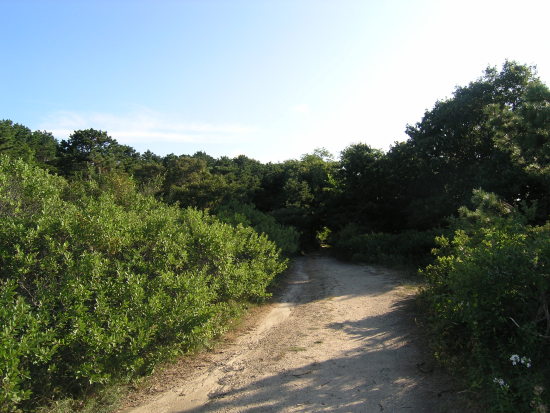
Thursday, June 2. 2022Outer Cape Cod upland flora, repostedCape Cod may have had a little bit of topsoil long ago, but now the Outer Cape (aka the Lower Cape - north of Chatham) is pretty much all sand (which is why the Indians needed to throw a herring into each hill of corn), and the dominant tree is the Pitch Pine. Where it's subject to wind, it doesn't get much higher than a 6' scrub form. Here's the path to our not-too-secret wild Blackberry patch, where it's not unusual to see a cheerful Eastern Box Turtle, to hear Bob Whites calling during the day, and Whip-Poor-Wills calling in the evening. Shrubs on front left, Beach Plum. Tree on right, Black Oak. Trees in background, Pitch Pine.
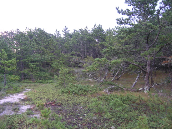
The basic outer Cape upland habitat is now Pitch Pine with an understory of Scrub Oak, with scatterings of Black Oak and feral Black Locust, with grasses below. In sunny spots, Bayberry, Blackberry, Poison Ivy, and Beach Plum. An occasional patch of wild blueberry filled with greedy Robins and Catbirds. This is officially known as Pitch Pine/Scrub Oak Barrens, but, for me, it's heaven. I hope that heaven, if I get there (doubtful) smells like hot sand, Pitch Pine, and Bayberry. The ground cover in the photo below is the dwarf shrub Common Bearberry with its small red berries in August. This was a foggy early morning:
Trackbacks
Trackback specific URI for this entry
No Trackbacks
Comments
Display comments as
(Linear | Threaded)
Most visitors to the Cape look elsewhere, and miss the distinct changes in the habitat and flora that occurs most noticeably around the Orleans rotary and beyond. Eastham, Wellfleet, Truro, and P'town generally do not support the dense understory typical of mid- and upper-Cape.
One advantage is less prevalence of poison ivy, the other is the fantastic light that results from sea on both sides, as well as a more open understory. It smells like no other place I have ever been. Upper and mid-Cape are just New England, outer Cape really is Cape Cod. Cape Cod starts at the Orleans traffic circle. Everything before that is a Boston suburb.
Musänica, is based in the United States, and sees itself as the premiere online music database, as well as a rapidly rising website connecting bands with their fan base. We are another way of turning music into a means of bringing people together.
What used to be the primary trees, if now you have pitch pine and scrub oak?
Good question, Sgt. Bob. Happens there's been some interesting work done on that, by analyzing pollen in the sediments of the kettle ponds.
This is probably more information than you want, but here goes, with excerpt from two papers' abstracts (and full citation should you want to track down the papers themselves): Parshall, T., D. R. Foster, E. Faison, D. MacDonald, and B. C. S. Hansen. 2003. LONG-TERM HISTORY OF VEGETATION AND FIRE IN PITCH PINE–OAK FORESTS ON CAPE COD, MASSACHUSETTS. Ecology 84:736–748. [doi:10.1890/0012-9658(2003)084[0736:LTHOVA]2.0.CO;2] "We use a paleoecological approach on Cape Cod, Massachusetts, to assess landscape-scale variation in pitch pine–oak vegetation and fire occurrence on the pre-European landscape and to determine changes resulting from European land use. Fossil pollen and charcoal preserved in seven lakes confirm a close link between landform and the pre-European distribution of vegetation. Pine forests, dominated by Pinus rigida, were closely associated with xeric outwash deposits, whereas oak–hardwood forests were associated with landforms having finer grained soils and variable topography. In general, fire was much more abundant on Cape Cod than most other areas in New England, but its occurrence varied geographically at two scales. On the western end of Cape Cod, fires were more prevalent in pine forests (outwash) than in oak–hardwood forests (moraines). In contrast, fires were less common on the narrow and north–south trending eastern Cape, perhaps because of physical limits on fire spread. The most rapid and substantial changes during the past 2000 years were initiated by European settlement, which produced a vegetation mosaic that today is less clearly tied to landform. Quercus and other hardwood trees declined in abundance in the early settlement period in association with land clearance, whereas Pinus has increased, especially during the past century, through natural reforestation and planting of abandoned fields and pastures. An increase in fossil charcoal following European settlement suggests that fire occurrence has risen substantially as a result of forest clearance and other land uses, reaching levels greater than at any time over the past 2000 years. Although fire was undoubtedly used by Native Americans and may have been locally important, we find no clear evidence that humans extensively modified fire regimes or vegetation before European settlement. Instead, climate change over the past several thousand years and European land use over the past 300 years have been the most important agents of change on this landscape." Marge Winkler and colleagues have specifically done work on Lower Cape ponds including the Wellfleet and Truro ponds I grew up swimming in: Winkler, M. G., and P. R. Sanford (1995), Coastal Massachusetts pond development: edaphic, climatic, and sea level impacts since deglaciation, Journal of Paleolimnology, 14(3), 311-336, doi:10.1007/bf00682431. "The earliest pollen and macrofossil assemblages in Group I [some of the ponds in Wellfleet and Truro] pond sediments suggest tundra and spruce-willow parklands before 12 000 yr B.P., boreal forest between 12 000 and 10 500 yr B.P., bog/heath initiation and expansion during the Younger Dryas between 11 000 and 10 000 yr B.P., northern conifer forest between 10 500 and 9500 yr B.P., and establishment of the Cape oak and pitch pine barrens vegetation after 9500 yr B.P." Hope this helps put some of this discussion into long-term context. In other words, it keeps changing as the climate changes.
It's more complex than that. Forests before 1492 in America were 'mostly' climax forests. If you are a mindless tree hugger you think that was good. But it defies knowledge of what the word 'climax' means in this context. It means something like "this is the end". Call me crazy but I prefer "this is the beginning'. After a forest burns or is clear cut if it were not replanted it would go through a very long cycle of growth, perhaps a few hundred years or longer, until it again reached a climax forest. BUT in the early stages it would be a rich diverse forest one where you could hunt deer and other animals. In pre-Columbian times the Indians would burn the forests to bring this regrowth/productive cycle out of the climax forest desert. The issue is more complex than presented and the apparent goals are less interesting than perceived.
Can't wait to visit the White Cedar Swamp trail on Marconi in a few weeks.
Looks like our territory, the NJ Pinelands. Pitch pine and scrub oak above, blueberry, inkberry, and bayberry in the understory, and around the streams, the Atlantic White Cedar--https://plants.ces.ncsu.edu/plants/chamaecyparis-thyoides/. It is always cooler, in the summer, in a cedar grove. They seem to bring their own coolness, and quiet, with them.
Your Pinelands and ours are a gift of the last Ice Age, which I am not at all eager to experience, so Global Warming is among the least of my concerns. |