As a favor to one of the local guides, I took part of an over flow party out on Lake Murray recently for a quick fishing trip. One of the clients was commenting on how my digital sonar looked a lot different than his. A discussion began about sonar, how it works and why my depth finder/sonar looked different that his. Sonar seems to be misunderstood as a fish finding technique even among experienced sports fishing fans so it might be fun to clear a few things up.
Echo location is a fairly well understood technique – transmit a signal, it reflects back a certain amount of energy to a receiver (or receivers), a quick calculation is made (return time) and the results displayed. Bats, whales and dolphins, certain fish and as unusual as this may sound, a bird species called cave swiftlet all have a means of echo locating objects and prey.
Sonar (SOund Navigation And Ranging) uses the mechanical propagation of a sound signal to locate a target's position. There are two main sonar techniques – passive and active. A good example of passive sonar is a relatively simple technique used in the late 15th Century – a simple open at both ends tube stuck into the water with a listener on the dry end to detect approaching ships. Anybody who's ever spent some time underwater on a busy lake with lots of boaters can relate to “listening” to the props move the boats through the water – that buzzing sound you hear is a form of passive sonar. A sailboat would produce a “whooshing” sound as the hull creates the bow wave.
Active sonar requires transmission of a signal at a set frequency – for recreational purposes this is usually a dual frequency signal transmitter of either 200 kHz (200 kiloHertz) or 50 kHz. The transmission works by generating a signal, passing this signal through a resonant crystal in a device called a transducer which then propagates through the water bounces off whatever is in the way and is returned to the receiver which calculates the time difference between transmission and reception. The reason there are two different frequencies is for signal control. 50 kHz will penetrate deeper with better accuracy than the higher 200 kHz frequency.
It is at this point that two issues have to be explained. First, the signal transmission/reception difference is measured in time, not in frequency shift. A shift in frequency is called Doppler Effect and is completely different. It is a common misconception. Second, the position of the transducer affects how much of the bottom you are seeing in relation to the boat. For example, if you have a transducer off the stern of your boat, you are actually seeing what is happening at the stern of the boat – not directly under the hull of the boat. The only way to see exactly what the sonar is displaying is to position the transducer in the middle of the boat using either a “shoot through the hull” fixture or cut a hole in the hull to put the transducer in contact with the water. All techniques have their advantages and disadvantages – it's really a matter of personal choice. The difficult one is the shoot through the hull – you lose signal strength, by setting the fixture in resin if there are air bubbles in the hull's glass resin you lose signal strength, mounting the shoot through fixture is tricky, etc. The best is the through hull (but be careful here too – on a go-fast fishing boat, not a lot of hull is in contact with the water at speed or cruise), the second best is off the stern. On my Ranger, I have two transducers, one off the stern and one attached to the trolling motor with a repeating display on the bow. I can switch between transducers as necessary to see what I'm looking for.
Ok, so we've explained the basics here – what do we do with this information? Use it of course. Take notes – there will be a quiz later.
The Display
The following is the sonar display as digitally signal processed. Remembering that we are looking at a 2 dimensional flat screen what can we tell about what we're actually seeing?
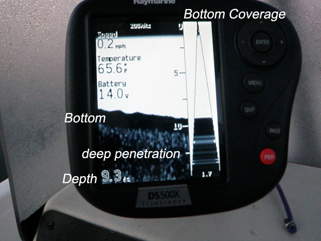
First look at the Bottom Coverage on the right hand top. This is a display of the actual signal as it propagates through the water. Notice that the depth is 9.3 feet (Depth, lower left) and the signal is 1.7 feet wide (at the bottom of the signal display) at the depth. So basically you are seeing1.7 feet of bottom in the active display at the stern and about half the length of the 20ft boat on the display to the left. The left hand display is a scrolling memory that is synched to the speed of the boat. As you can see from the deep penetration, the signal at this depth is powerful enough spread through the sediment and scatter the return signal. It is seeing an additional five feet into the bottom – sonar has the same signal properties as radar has meaning that it can see behind the more solid bottom into the mud, it is just not as defined.
If you look at the whole display you see a slight slope from 9 feet to 7 feet stern to bow with about a foot of dense material making up the bottom. Pretty good huh? You can see underwater, albeit only in two dimensions.
Structure
Fishing is a game - finding fish, presenting a lure, enticing the bite and making the catch. In the good old days, (say late '50s and before) you could pretty much chuck anything anywhere on a lake and catch something. This was also true of salt water fishing. It was largely a “sport” that was used to catch the occasional dinner – catch and release was in it's infancy. As fishing pressure increased with the popularity of boating, the introduction of specialized recreational fishing boats and the increase of sophisticated gear, lures and techniques, fish became somewhat harder to find. This led a gentleman by the name of Al Linder to invent a scheme known as the In-Fisherman “system”. This system had been a closely held secret of professional guides everywhere. Specifically, the “system” gave away the fact that fish like structure. Structure can be defined as pretty much anything that will hold fish – a hump, hill, submerged tree line, rocks along a waterway, underwater anything (even buoys), floating docks – anything that floats, reefs – I think you understand the point.
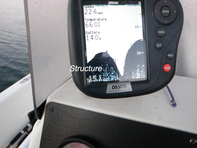
The display above is showing basic structure. All the elements of the type of bottom profile that will hold fish at a decent depth are there. If you look closely, you can see little bits sticking up out of the hummocks – those would be tree stumps or brush that was submerged when the lake was filled. Those will also hold fish at certain times of the year. There aren't any fish on this structure at this time of year because the water is changing over from summer to winter – they have moved much deeper or moved into coves and further up the lake.
Display Interpretation
“How do you tell that there are fish in the area or holding on some type of structure? My display doesn't look anything like the manual.” That's a pretty common question asked back in my days as a fishing guide. The answer is not complicated – it involves how you set up your display and other factors.
All fish have what is called a swim bladder. This is a pocket of air which has a different density than the water the fish is swimming in. Which means that the shape of the signal changes as it is reflected back to the receiver. Sonar manuals will often use the classic upside down “whoosh” or arch shape to indicate the location of the fish.
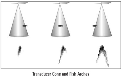
While this is the classic approach to demonstrating how fish are displayed, the actual shape of the target is determined by boat speed, signal ping rate, magnification of the display, how the signal/noise rejection is configured, the angle of the fish to the sonar beam, whether the fish is swimming up or down, etc. It sounds very complicated, but all these factors still present a target – and you need to be able to discern what the target is.
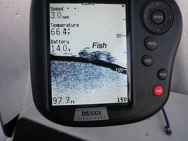
In the image above you can see a typical fish/bait/structure scenario. Notice that they are on the side of a hill facing down. If you look close you'll see the slight arch shape of the larger fish hovering around the cloud. That cloud is structure – maybe some brush or a fallen tree top and bait fish hanging in and around the structure – the longer slightly arched targets are stripers at this depth I would suspect.
What would be another display that we might see that needs interpretation? I'm glad you asked.
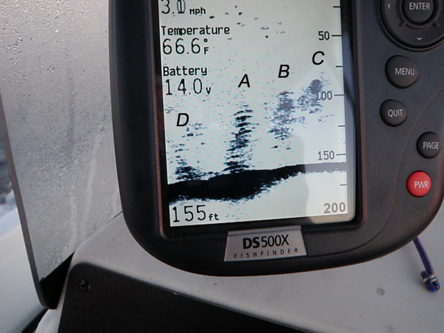
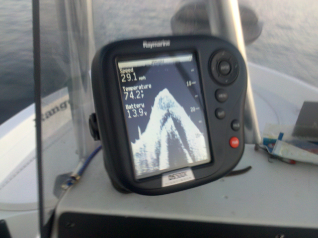
The image above is one of those “WTH?” moments when you are trolling or just looking for a place to drop a line. First of all, we're looking at 150' of water. There is no discernible “structure” for fish to hide in and around – the bottom is flat. You're looking at silt over bedrock. Let's do it by the numbers – or letters.
A – Fish stack or tree? First glance would seem to indicate a old fir or pine tree free standing on a flat plain. But it's leaning so that isn't indicative of a tree – in particular in silt. There are longer streaks with slight arches so that would indicate fish, but fish that normally hold at these depths aren't “large” - or at least as large as the signal cone here indicates. So what's going on?
Moving fish. When you get longer arches, in particular at depth, the fish are moving faster than you are. That's how you get that elongated shape. Stripers will stack like this when chasing bait – the reason is that they always look forward and up – they aren't quite like other predator fish who just look forward and slightly down.
B – A demonstration of a separated bait ball. Looking close you will see two to three small fish busting the bait ball up. Remember, this is picture of a set piece of time – a snapshot. The fish noted in A are probably busy busting their own bait, or they may be picking off remnants of the B bait ball that is being broken up.
C – Bait ball. A very tight concentration of bait fish. There may be a fish or two attempting to bust the ball up, but more likely, based on this picture, if there is a fish or two in there, they are picking off stragglers outside the ball rather than break it up.
D – Remnants of A reforming. There may be a fish or two hanging around, but it is unlikely.
But what about the structure you may want to ask. There isn't any. This is an active feeding scenario – no structure required.
So far we've discussed usual questions about fish finding using sonar. We've learned about signal cones, frequencies, display set up, depth contours and structure, fish arches and how to interpret some typical types of display information necessary to find and hopefully catch fish. Is their something else we need to know concerning sonar?
Well, maybe. Time for a quiz – two images and I'll let you tell me what they are.
Image #1
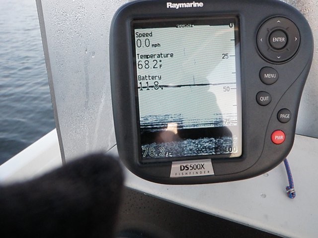
Image #2
There is enough information in both of these to make a reasonable guess. I'll even give you a hint about Image #2 – you've seen this before. Think 2D. Answers in the comments.
To wrap it all up, getting used to what your sonar is telling you is important, but it is only part of the whole – at least in terms of boat fishing.
Next up – we'll discuss using the sonar in conjunction with reading surface water, how drifting affects sonar use, surface vs depth temperature and a few other goodies.
Any suggestions for future topics would be very appreciated.